-

Deutsch
Burgeis 1210 m
In der Nähe von: Plantapatschhütte, Mals, Glurns, Haidersee/Lago della Muta
Fotos (1)
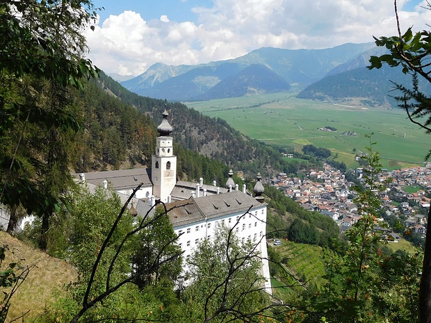
Kloster Marienberg © Ole
Minimap
0Km
Klicke um zu zeichnen. Klicke auf den letzten Punkt um das Zeichnen zu beenden
Tourenberichte (1)
| Trentino-Südtirol | T2 |
|
Wanderung im Ober-Vinschgau
Von St. Valentin auf der Haide zum Berggasthof Paflur 1550 m
Wegpunkte: Burgeis, Malles Venosta, Tartsch, Schluderns, Churburg, Ortlerblick, Berggasthof Paflur
Publiziert von
2. Februar 2014 um 15:35
Hikr.org hat wenige Berichte für diesen Wegpunkt.
Du kannst jetzt einen Tourenbericht eintragen, oder suchen in der "In der Nähe" Liste.
Du kannst jetzt einen Tourenbericht eintragen, oder suchen in der "In der Nähe" Liste.
Berichte in der Nähe
| Unterengadin | ZS |
22 Aug 23
|
 Mit dem E-Bike rund um den Nationalpark
Eigentlich wollte ich keinen Bericht schreiben. Vor allem keinen langen ;-) Aber jetzt habe ich mich doch dazu entschieden. Nur um ein paar Tips zu geben.
Ich habe mich bewusst nicht nur für eine Route entschieden, sondern Etappen von verschiedenen Routen kombiniert. Vor allem wollte ich die Uina Schlucht sehen......
Publiziert von
11. September 2023 um 20:16
(Fotos:15 | Geodaten:5)
| Trentino-Südtirol | T3+ |
12 Aug 23
|
 – Rasassspitze (2941 m) – Grionkopf (2896m)") Kurzweilige Rojener Runde: Seebödenspitze (2859 m) – Rasassspitze (2941 m) – Grionkopf (2896m)
Kurzweilige Rojener Runde: Seebödenspitze (2859 m) – Rasassspitze (2941 m) – Grionkopf (2896m)
Eine schöne, abwechslungsreiche, meist einsame Runde mit Blick auf vielfältige Berggestalten.
Start im Rojental in einer Kurve kurz nach dem Abzweig nach Rojen, dort ist ein kleiner Parkplatz. Es geht kurz ins Rojental hinein. Nach wenigen Minuten links hinauf auf Weg 8a, an der Rojen-Skihütte vorbei durch den Wald (statt auf...
Publiziert von
14. August 2023 um 22:05
(Fotos:31)
| Prättigau | T3+ |
24 Jun 23
|
 Von Liechtenstein nach Italien
Etwas durchwachsen, es verlief nicht alles wie geplant. Ein Bericht.
Unsere diesjährige Tour führte in elf Etappen von Malbun (Liechtenstein) bis nach Glurns (Südtirol), durch das Prättigau (Schesaplana-Gebiet, Klosters, Davos) und das Unterengadin.
Etappe 1: von Malbun auf die Pfälzerhütte (Karte)
Länge: 7km, auf:...
Publiziert von
13. Juli 2023 um 18:13
(Fotos:20)
| Trentino-Südtirol | T2 |
6 Aug 22
|
 nach Burgeis") Vom Matschertal über die Spitzige Lun (2324 m) nach Burgeis
Vom Matschertal über die Spitzige Lun (2324 m) nach Burgeis
Vortag siehe: Rund um Burgeis
Für den heutigen Tag waren einige Regenfälle vorher gesagt. So entschieden wir uns für eine Wanderung auf die Spitzige Lun, den Hausberg von Mals. Die Spitzige Lun (2324 m) ist der südwestliche Ausläufer des Bergrückens, der das Matschertal vom Planeiltal trennt. Durch seine vorgeschobene...
Publiziert von
3. September 2022 um 17:57
(Fotos:23)
| Trentino-Südtirol | T2 |
5 Aug 22
|
 Rund um Burgeis
Vortag siehe: Piz Daint (2968 m) - Schöner Aussichtsgipfel am Ofenpass
Nachdem wir die letzten Tage einige Bergtouren im weiteren Umfeld von unserem Urlaubsort Burgeis unternommen hatten, wollten wir heute eine kleine Rundwanderung in Dorfnähe machen.Burgeis, das seinen Dorfcharakter noch bewahrt hat, liegt nördlich der...
Publiziert von
30. August 2022 um 20:24
(Fotos:21)


