
Madagascar: Big Tsingy de Bemaraha Trail
|
||||||||||||||||||||||


Big Tsingy de Bemaraha
Parco Nazionale Tsingy de Bemaraha
Tsingy de Bemaraha, situato sulla costa occidentale del Madagascar in un Parco Nazionale, è noto per le sue formazioni calcaree mozzafiato.
È un sito da non perdere in visita in Madagascar.
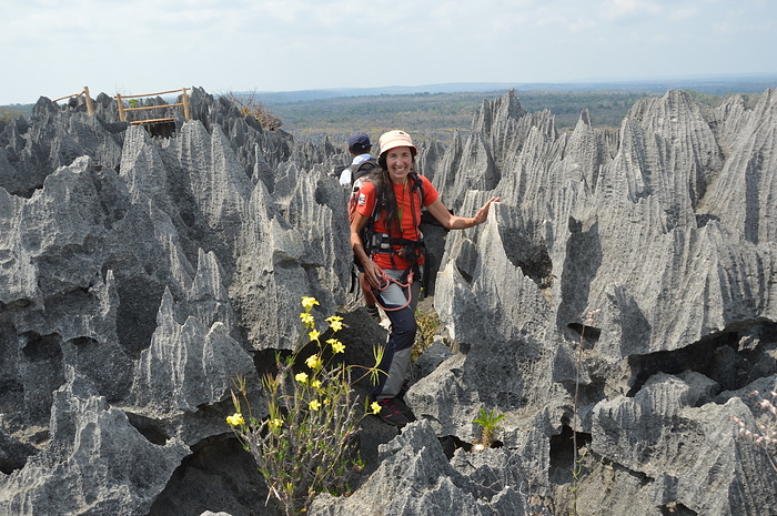
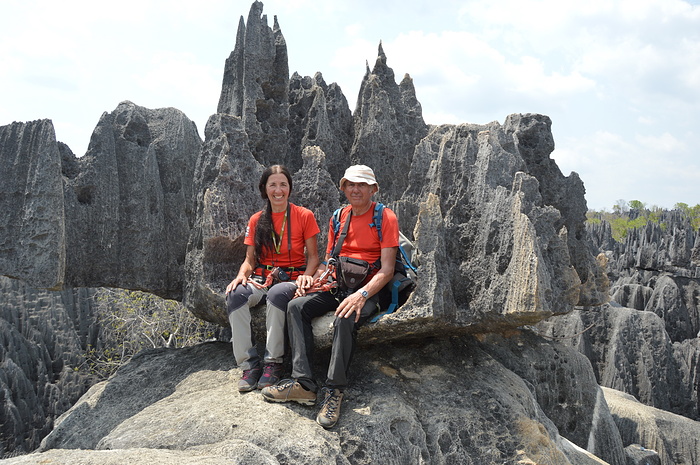
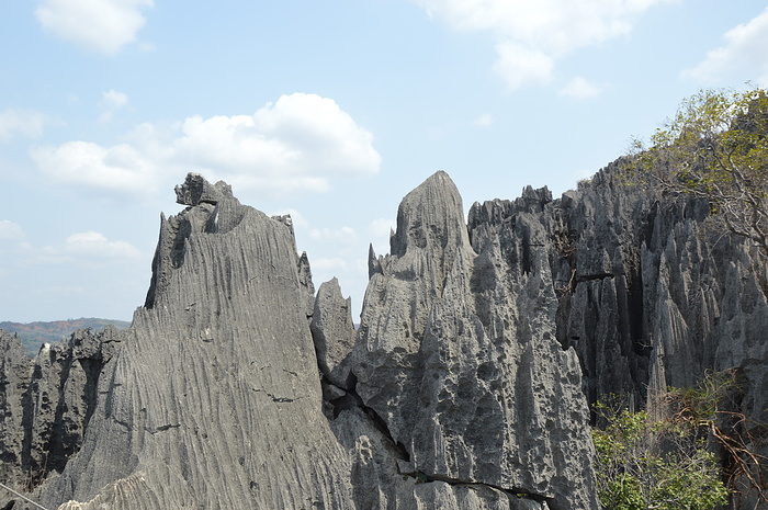
Mentre il paese è noto per i lemuri, il birdwatching, i baobab e le giungle, Tsingy de Bemaraha offre ai visitatori un'esperienza leggermente diversa, ospita la formazione geologica più strabiliante e unica al mondo, gli Tsingy sono caratterizzati da giganteschi pietre calcaree con cime frastagliate.
L'intero Parco è largo 583 chilometri quadrati e prende il nome dalla parola malgascia Tsingy, che significa "dove non si può camminare a piedi nudi o in punta di piedi".
Questo nome ha senso dopo aver visto la natura appuntita dei molteplici dintorni intorno al parco, contrassegnati da una foresta labirintica di giganteschi aghi calcarei.
La formazione degli Tsingy iniziò circa 200 milioni di anni fa, quando strati di calcite sul fondo di una laguna formarono uno spesso letto di calcare. Successivamente, l'attività tettonica ha innalzato il calcare e, con l'abbassamento del livello del mare durante le ere glaciali del Pleistocene, è stata esposta una quantità ancora maggiore di calcare.
Negli anni l'erosione idrica ha formato una fitta rete di abbaglianti anfratti, canyon, faglie, ecc.
Per la sua unicità, il parco è stato dichiarato patrimonio dell'UNESCO nel 1990. La riserva mostra una fauna e una flora mozzafiato segnate da gole, canyon, montagne, laghi e paludi di mangrovie.
Queste formazioni mozzafiato offrono un vantaggio secondario, il paesaggio insolito e spietato della zona l'ha resa un'ottima dimora per varie specie endemiche di piante e animali. La parte occidentale del parco è ricoperta da boschi secchi di latifoglie particolarmente adatti al clima in continua evoluzione della zona.
Serene savane erbose e cespugli di pianura costituiscono la parte orientale. Poiché è molto umido tra le alte formazioni Tsingy, all'interno dei canyon si possono trovare aree di foreste tropicali ventilate e liane.
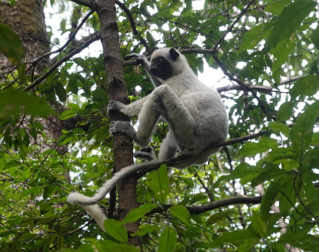
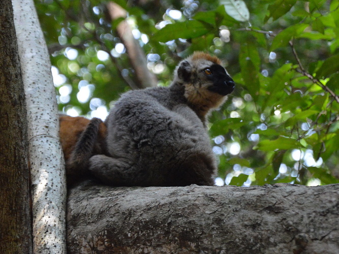
Potresti trovare 11 specie di lemuri in questo parco. Il lemure nano dalla coda grassa, il sifaka di decken, il lemure lanoso di Cleese, il lemure topo grigio, il lemure marrone dalla fronte rossa e il lemure di bambù minore di Sambirano sono tra le specie esclusive qui.
Anche il minuscolo falanouc carnivoro e la mangusta dalla coda ad anelli, così come alcuni pipistrelli, sono abitanti.
Il parco ospita più di 100 specie di uccelli accattivanti, tra cui l'aquila pescatrice del Madagascar e l'ibis crestato, in grave pericolo di estinzione, il ralliccio del Madagascar, il coua gigante e la bobina di conquista
Per entrare nella riserva naturale rigorosa di Tsingy de Bemaraha, i viaggiatori dovranno pagare una tassa
Tsingy de Bemaraha National Park
Tsingy de Bemaraha, situated on the western coast of Madagascar in a National Park, is known for its breathtaking limestone formations.
It is a must-see site visiting Madagascar.
While the country is known for lemurs, birding, baobab trees, and jungles, Tsingy de Bemaraha provides visitors with a little different experience, it is home to the most mind-blowing and unique geological formation in the world, the Tsingy are marked by gigantic limestone stones with jagged peaks.
The whole Park is 583 Kilometer square wide derives its name from the Malagasy word Tsingy, meaning, ''where one cannot walk barefoot, or walk on tiptoes''
This name make sense after you see the spiky nature of the multiple surroundings around the park, marked by a labyrinth forest of gigantic limestone needles.
The formation of the Tsingy began some 200 million years ago when layers of calcite at the bottom of a lagoon formed a thick limestone bed. Later, tectonic activity elevated the limestone, and as sea levels fell during the Pleistocene ice ages, even more of the limestone was exposed.
In the years the water erosion formed a dense network of dazzling crevices, canyons, faults, etc.
Due to its uniqueness, the park was declared a UNESCO heritage site in 1990. The reserve displays breathtaking fauna and flora marked by gorges, canyons, mountains, lakes, and mangrove swamps.
These breathtaking formations offer a secondary benefit, the unusual and unforgiving landscape of the area has made it an excellent habitation for various endemic species of plants and animals. The western part of the park is covered by deciduous dry forests which are particularly suited to the area's constantly changing climate.
Serene grassy savannas and lowland bushes make up the eastern portion. Since it's very humid among the tall Tsingy formations, areas of breezy tropical forests and lianas can be found within the canyons.
You may find 11 species of lemur in this park. The fat-tailed dwarf lemur, decken's sifaka, Cleese's woolly lemur, grey mouse lemur, red-fronted brown lemur, and Sambirano lesser bamboo lemur are among the species that are exclusive here.
The tiny carnivorous falanouc and ring-tailed mongoose, as well as some bats, are also inhabitants.
The park is home to more than 100 eye-catching bird species, including the severely endangered Madagascar fish eagle and crested ibis, Madagascar wood rail, giant coua, and conquer's coIl
To enter Tsingy de Bemaraha Strict Nature Reserve, travelers will need to pay a fee
Accesso
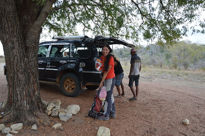
Base di partenza per l'escursione agli Tsingy è Bekopaka (alberghi).
Da qui 17 km di strada, percorribile solo con un fuoristrada in 2 ore, portano ai parcheggi punto di inizio delle escursioni.
Nelle vicinanze c'è anche un piccolo aeroporto dove si può arrivare solo con voli privati.
Bekopaka si raggiunge da Belo sur Tsiribihina, sono 90 km di strada statale comunque percorribile, in circa 4 ore, solo con un veicolo fuoristrada, inoltre gli ultimi 20 km si devono percorrere in convoglio scortati dalla gendarmeria, quindi alle 4 ore va aggiunto il tempo necessario alla attesa di altre auto per la formazione del convoglio.
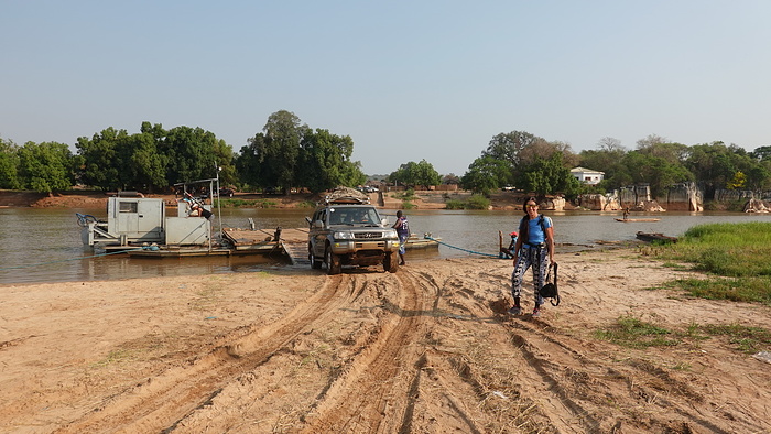
Poi, ultimo ostacolo l'attraversamento del fiume Manambolo su una piccola chiatta.
Anche arreivare a Belo sur Tsiribihina non è uno scherzo, noi siamo arrivati scendendo in battello lungo il bellissimo fiume Tsiribihina (2 giorni e mezzo con partenza da Miandrivazo)
Una alternativa è raggiungere Morondava con un volo interno, poi 120 km di pista percorribili in 4 ore e attraversamento del fiume Tsiribihina su una chiatta.
Access
The starting point for the excursion to the Tsingy is Bekopaka (hotels).
From here 17 km of road, passable only with an off-road vehicle in 2 hours, lead to the car parks, the starting point of the excursions.
Nearby there is also a small airport which can only be reached by private flight.
Bekopaka can be reached from Belo sur Tsiribihina, there are 90 km of national road which can still be traveled in about 4 hours, only with an off-road vehicle, furthermore the last 20 km must be covered in a convoy escorted by the gendarmerie, therefore the required to wait for other cars to form the convoy must be added to the 4 hours.
Then, the last obstacle is the crossing of the Manambolo river on a small barge.
Even getting to Belo sur Tsiribihina is no joke, we arrived by boat along the beautiful Tsiribihina river (2 and a half days departing from Miandrivazo)
An alternative is to reach Morondava with an internal flight, then 120 km of track that can be covered in 4 hours and crossing the Tsiribihina river on a barge.
Escursione
L'escursione è effettuabile solo pagando i diritti di accesso al parco e accompagnati da una guida locale (sede del parco a Bekopaka)
La guida fornisce imbragatura con cordino e moschettone (no kit da ferrata e caschetto per il percorso)
Esistono 3 percorsi:
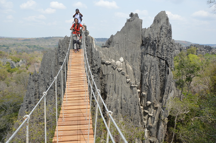
Circuit Andamozavaky - dall'omonimo parcheggio raggiunge i punti panoramici 2 e 3 e utilizza il secondo ponte sospeso
Circuit Ranotsara - dall'omonimo parcheggio raggiunge il punto panoramico 1 con il terzo si raggiunge il punto panoramico 1 e il primo ponte sospeso
Circuit Broadway - collega i due precedenti ed è un lungo percorso accidentato nella foresta popolata dai lemuri
Nel concordare l'itinerario con la guida è necessario fornire delle credenziali sulla propria esperienza, noi abbiamo fatto vedere alcune nostre foto in montagna.
Noi abbiamo optato la combinazione dei tre percorsi-
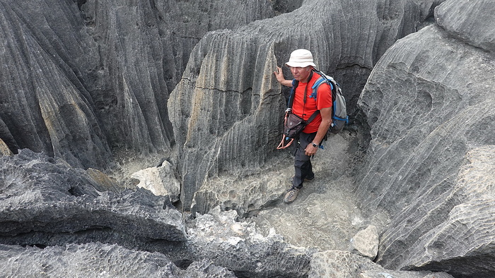
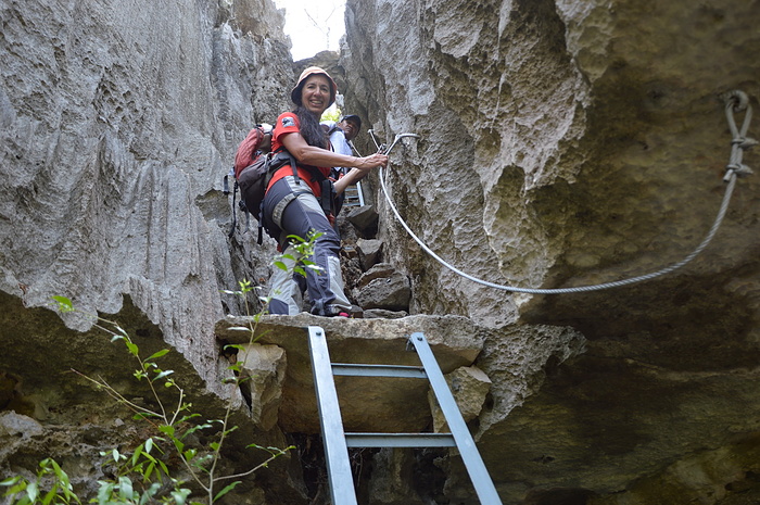
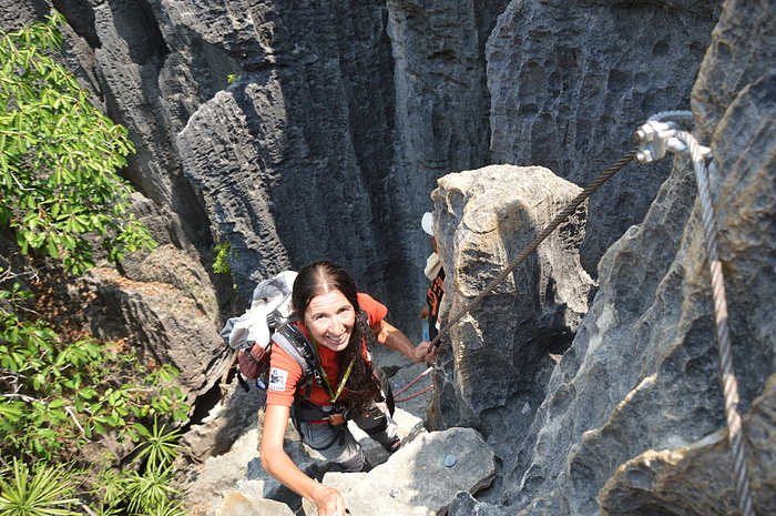
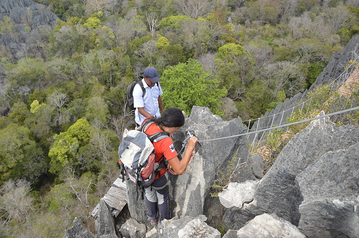
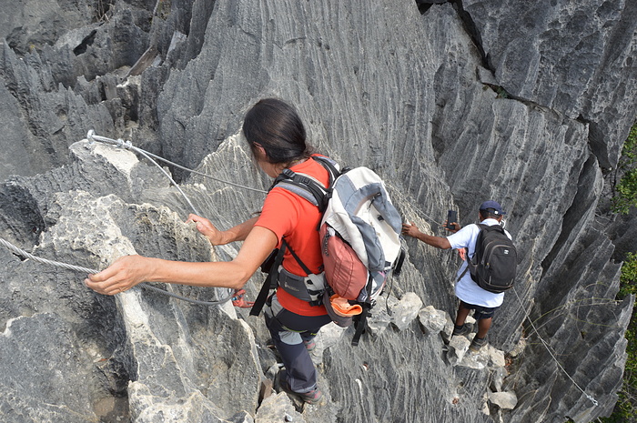
La ferrata è facile, vi sono numerose scalette, i fittoni in ferro sono sostituiti con dei blocchi di calcare fissati alla roccia e un filo metallico accompagna il percorso dove necessario.
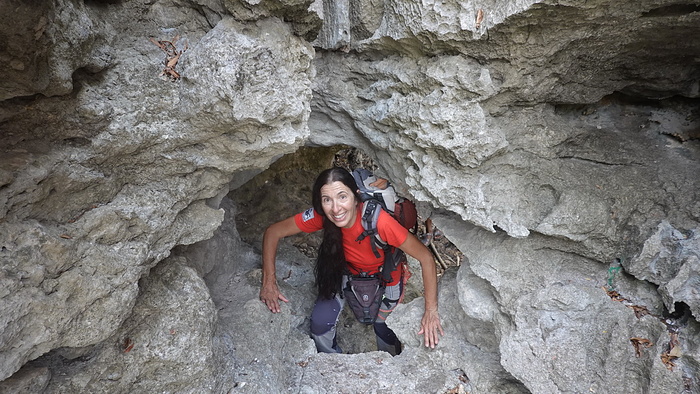
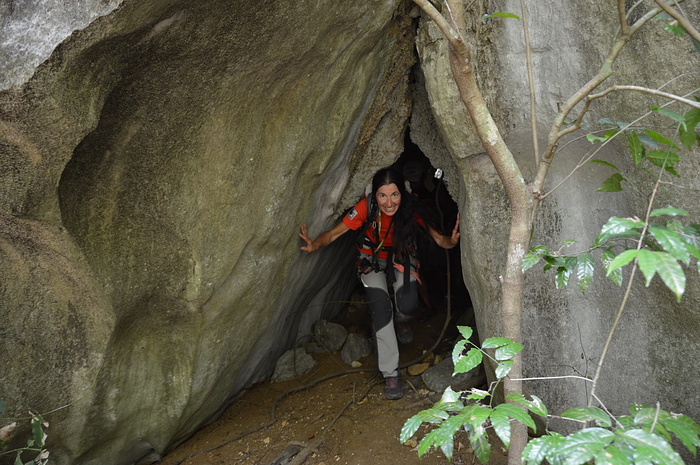
Si devono attraversare numerose strettoie e grotte (necessaria una lampada)
E' presente una ricca fauna, abbiamo avvistato numerosi lemuri di varie specie, uccelli e rettili, una mangosta nel tratto finale sembra faccia accoglienza a tutti gli escursionisti.
Ne corso dell'escursione non abbiamo trovato nessuno.
Come detto la ferrata è facile, però si cammina attraversando una serie infinita di affilatissime lame di calcare delle dimensioni da decine di metri a pochi centimetri, quindi bisogna stare attenti a non tagliarsi, un banale inciampo potrebbe avere serie conseguenze anche in relazione a dove ci si trova.
Excursion
The excursion can only be carried out by paying the park access fees and accompanied by a local guide (park headquarters in Bekopaka)
The guide supplies a harness with lanyard and carabiner (no via ferrata kit and helmet for the route)
There are 3 routes:
Circuit Andamozavaky - from the parking lot of the same name reaches viewpoints 2 and 3 and uses the second suspension bridge
Circuit Ranotsara - from the parking lot of the same name it reaches the panoramic point 1 with the third one you reach the panoramic point 1 and the first suspension bridge
Circuit Broadway - connects the previous two and is a long bumpy ride through the forest populated by lemurs
When agreeing the itinerary with the guide, it is necessary to provide credentials on your experience, we have shown some of our photos in the mountains.
We have opted for the combination of the three circuits.
The via ferrata is easy, there are numerous ladders, the iron posts are replaced with limestone blocks fixed to the rock and a metal wire accompanies the route where necessary.
Numerous bottlenecks and caves have to be crossed (lamp required)
There is a rich fauna, we have sighted numerous lemurs of various species, birds and reptiles, a mangoster in the final stretch seems to welcome all hikers.
During the excursion we did not find any people.
As mentioned, the via ferrata is easy, but you walk through an infinite series of very sharp limestone blades ranging from tens of meters to a few centimeters in size, so you have to be careful not to cut yourself, a trivial stumble could have serious consequences also in relation to the place where you are.
Percorso
Dal parcheggio (Entree Ranotsara) si cammina nella foresta, raggiunto un tabellone informativo si segue il sentiero di destra, dopo poco iniziano le prime strettoie e i primi tratti attrezzati (Circuit Ranotsara), si sale poi ripidamente al primo punto panoramico, preceduto e seguito da un tratto pianeggiante in mezzo a una serie di affilatissime lame.
La vista è mozzafiato sulle guglie circostanti.
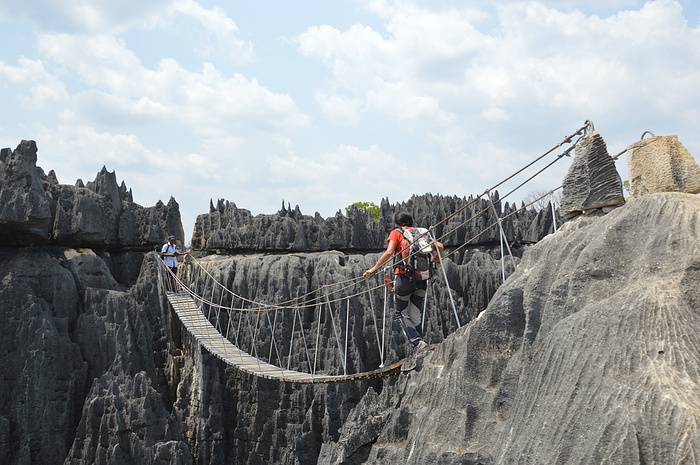
Una ripidissima discesa conduce al primo ponte sospeso, poi ancora una discesa ripida ed esposta porta alla foresta.
Qui inizia il "Circuit Broadway" lungo x km., si procede nella foresta con numerosi saliscendi superando tratti rocciosi, strettoie e grotte con la compagnia dei lemuri.
Si raggiungono le prime scale del "Circuit Andamozavaky" che, con una ripida salita sul fondo delle spaccature che separano le varie guglie, conduce al secondo belvedere.
Si scende brevemente al secondo ponte sospeso per poi salire al terzo belvedere.
Da qui una ripidissima serie di scale consente la discesa superando una serie stretti passaggi tra le guglie per poi percorrere un tratto di foresta e arrivare al parcheggio di Andamozavaky.
Tutto il percorso comprende vari tratti sotteranei, più o meno bui per cui è consigliato avere a disposizione una lampada.
Itinerary
From the parking lot (Entree Ranotsara) you walk in the forest, once you reach an information board, you follow the path to the right, after a while the first crevices bottlenecks and the first equipped sections (Circuit Ranotsara), you then climb steeply to the first panoramic point, preceded and followed by a flat stretch amidst a series of razor-sharp blades.
The view is breathtaking on the surrounding needles.
A very steep descent leads to the first suspension bridge, then another steep and exposed descent leads to the forest.
Here begins the "Circuit Broadway" x km long, proceeding in the forest with numerous ups and downs overcoming rocky crevices, canyons and caves with the company of lemurs.
You reach the first ladder of the "Circuit Andamozavaky" which, with a steep climb on the bottom of the cracks that separate the various needles, leads to the second viewpoint.
Descend briefly to the second suspension bridge and then climb to the third belvedere.
From here a very steep series of ladderrs allows the descent overcoming a series of narrow passages between the pinnacles to then cross a stretch of forest and arrive at the Andamozavaky parking lot.
The entire route includes various underground sections, more or less dark, for which it is advisable to have a lamp available.
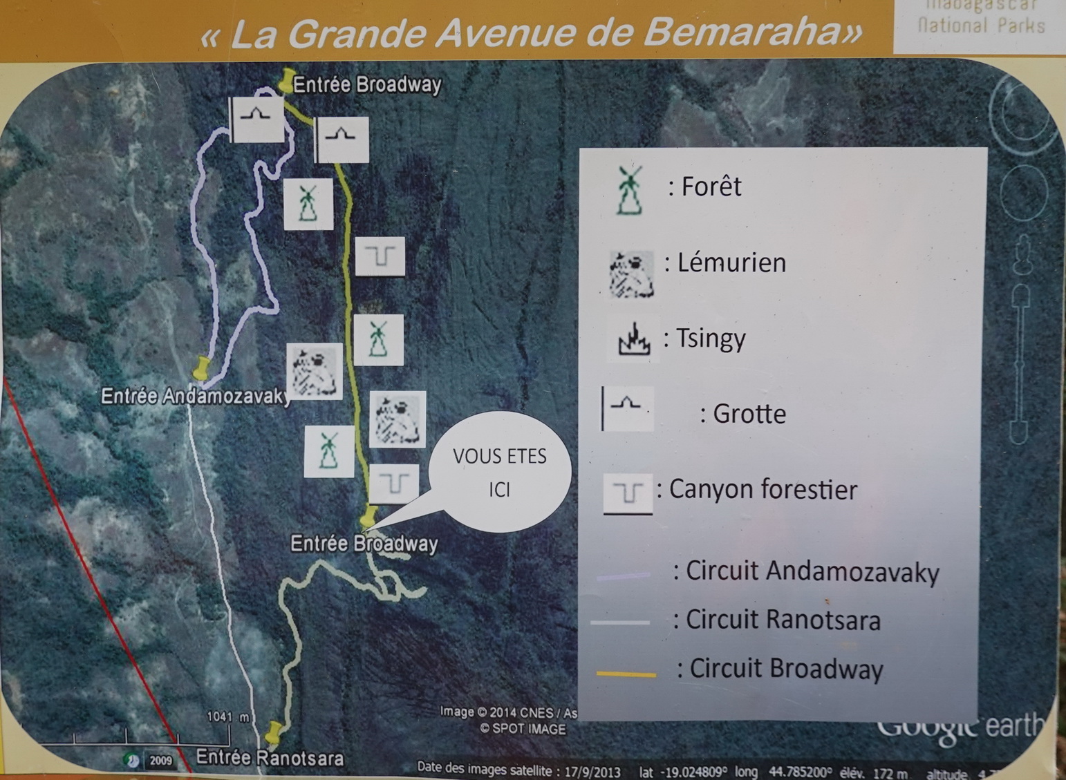
Tsingy Map

Organizzazione
Per l'organizzazione del nostro giro ci siamo rivolti all'agenzia locale "Travels of Madagascar" gestita la Roberto Cioce (vedi)
Tour organization
our tour was organized by the local agency "Travels of Madagascar" managed by Roberto Cioce (link)
 |
 |
Tsingy de Bemaraha, situato sulla costa occidentale del Madagascar in un Parco Nazionale, è noto per le sue formazioni calcaree mozzafiato.
È un sito da non perdere in visita in Madagascar.
Mentre il paese è noto per i lemuri, il birdwatching, i baobab e le giungle, Tsingy de Bemaraha offre ai visitatori un'esperienza leggermente diversa, ospita la formazione geologica più strabiliante e unica al mondo, gli Tsingy sono caratterizzati da giganteschi pietre calcaree con cime frastagliate.
L'intero Parco è largo 583 chilometri quadrati e prende il nome dalla parola malgascia Tsingy, che significa "dove non si può camminare a piedi nudi o in punta di piedi".
Questo nome ha senso dopo aver visto la natura appuntita dei molteplici dintorni intorno al parco, contrassegnati da una foresta labirintica di giganteschi aghi calcarei.
La formazione degli Tsingy iniziò circa 200 milioni di anni fa, quando strati di calcite sul fondo di una laguna formarono uno spesso letto di calcare. Successivamente, l'attività tettonica ha innalzato il calcare e, con l'abbassamento del livello del mare durante le ere glaciali del Pleistocene, è stata esposta una quantità ancora maggiore di calcare.
Negli anni l'erosione idrica ha formato una fitta rete di abbaglianti anfratti, canyon, faglie, ecc.
Per la sua unicità, il parco è stato dichiarato patrimonio dell'UNESCO nel 1990. La riserva mostra una fauna e una flora mozzafiato segnate da gole, canyon, montagne, laghi e paludi di mangrovie.
Queste formazioni mozzafiato offrono un vantaggio secondario, il paesaggio insolito e spietato della zona l'ha resa un'ottima dimora per varie specie endemiche di piante e animali. La parte occidentale del parco è ricoperta da boschi secchi di latifoglie particolarmente adatti al clima in continua evoluzione della zona.
Serene savane erbose e cespugli di pianura costituiscono la parte orientale. Poiché è molto umido tra le alte formazioni Tsingy, all'interno dei canyon si possono trovare aree di foreste tropicali ventilate e liane.
Potresti trovare 11 specie di lemuri in questo parco. Il lemure nano dalla coda grassa, il sifaka di decken, il lemure lanoso di Cleese, il lemure topo grigio, il lemure marrone dalla fronte rossa e il lemure di bambù minore di Sambirano sono tra le specie esclusive qui.
Anche il minuscolo falanouc carnivoro e la mangusta dalla coda ad anelli, così come alcuni pipistrelli, sono abitanti.
Il parco ospita più di 100 specie di uccelli accattivanti, tra cui l'aquila pescatrice del Madagascar e l'ibis crestato, in grave pericolo di estinzione, il ralliccio del Madagascar, il coua gigante e la bobina di conquista
Per entrare nella riserva naturale rigorosa di Tsingy de Bemaraha, i viaggiatori dovranno pagare una tassa
 |
 |
Tsingy de Bemaraha, situated on the western coast of Madagascar in a National Park, is known for its breathtaking limestone formations.
It is a must-see site visiting Madagascar.
While the country is known for lemurs, birding, baobab trees, and jungles, Tsingy de Bemaraha provides visitors with a little different experience, it is home to the most mind-blowing and unique geological formation in the world, the Tsingy are marked by gigantic limestone stones with jagged peaks.
The whole Park is 583 Kilometer square wide derives its name from the Malagasy word Tsingy, meaning, ''where one cannot walk barefoot, or walk on tiptoes''
This name make sense after you see the spiky nature of the multiple surroundings around the park, marked by a labyrinth forest of gigantic limestone needles.
The formation of the Tsingy began some 200 million years ago when layers of calcite at the bottom of a lagoon formed a thick limestone bed. Later, tectonic activity elevated the limestone, and as sea levels fell during the Pleistocene ice ages, even more of the limestone was exposed.
In the years the water erosion formed a dense network of dazzling crevices, canyons, faults, etc.
Due to its uniqueness, the park was declared a UNESCO heritage site in 1990. The reserve displays breathtaking fauna and flora marked by gorges, canyons, mountains, lakes, and mangrove swamps.
These breathtaking formations offer a secondary benefit, the unusual and unforgiving landscape of the area has made it an excellent habitation for various endemic species of plants and animals. The western part of the park is covered by deciduous dry forests which are particularly suited to the area's constantly changing climate.
Serene grassy savannas and lowland bushes make up the eastern portion. Since it's very humid among the tall Tsingy formations, areas of breezy tropical forests and lianas can be found within the canyons.
You may find 11 species of lemur in this park. The fat-tailed dwarf lemur, decken's sifaka, Cleese's woolly lemur, grey mouse lemur, red-fronted brown lemur, and Sambirano lesser bamboo lemur are among the species that are exclusive here.
The tiny carnivorous falanouc and ring-tailed mongoose, as well as some bats, are also inhabitants.
The park is home to more than 100 eye-catching bird species, including the severely endangered Madagascar fish eagle and crested ibis, Madagascar wood rail, giant coua, and conquer's coIl
To enter Tsingy de Bemaraha Strict Nature Reserve, travelers will need to pay a fee
 |
 |
Base di partenza per l'escursione agli Tsingy è Bekopaka (alberghi).
Da qui 17 km di strada, percorribile solo con un fuoristrada in 2 ore, portano ai parcheggi punto di inizio delle escursioni.
Nelle vicinanze c'è anche un piccolo aeroporto dove si può arrivare solo con voli privati.
Bekopaka si raggiunge da Belo sur Tsiribihina, sono 90 km di strada statale comunque percorribile, in circa 4 ore, solo con un veicolo fuoristrada, inoltre gli ultimi 20 km si devono percorrere in convoglio scortati dalla gendarmeria, quindi alle 4 ore va aggiunto il tempo necessario alla attesa di altre auto per la formazione del convoglio.
Poi, ultimo ostacolo l'attraversamento del fiume Manambolo su una piccola chiatta.
Anche arreivare a Belo sur Tsiribihina non è uno scherzo, noi siamo arrivati scendendo in battello lungo il bellissimo fiume Tsiribihina (2 giorni e mezzo con partenza da Miandrivazo)
Una alternativa è raggiungere Morondava con un volo interno, poi 120 km di pista percorribili in 4 ore e attraversamento del fiume Tsiribihina su una chiatta.
 |
 |
The starting point for the excursion to the Tsingy is Bekopaka (hotels).
From here 17 km of road, passable only with an off-road vehicle in 2 hours, lead to the car parks, the starting point of the excursions.
Nearby there is also a small airport which can only be reached by private flight.
Bekopaka can be reached from Belo sur Tsiribihina, there are 90 km of national road which can still be traveled in about 4 hours, only with an off-road vehicle, furthermore the last 20 km must be covered in a convoy escorted by the gendarmerie, therefore the required to wait for other cars to form the convoy must be added to the 4 hours.
Then, the last obstacle is the crossing of the Manambolo river on a small barge.
Even getting to Belo sur Tsiribihina is no joke, we arrived by boat along the beautiful Tsiribihina river (2 and a half days departing from Miandrivazo)
An alternative is to reach Morondava with an internal flight, then 120 km of track that can be covered in 4 hours and crossing the Tsiribihina river on a barge.
 |
 |
L'escursione è effettuabile solo pagando i diritti di accesso al parco e accompagnati da una guida locale (sede del parco a Bekopaka)
La guida fornisce imbragatura con cordino e moschettone (no kit da ferrata e caschetto per il percorso)
Esistono 3 percorsi:
Circuit Andamozavaky - dall'omonimo parcheggio raggiunge i punti panoramici 2 e 3 e utilizza il secondo ponte sospeso
Circuit Ranotsara - dall'omonimo parcheggio raggiunge il punto panoramico 1 con il terzo si raggiunge il punto panoramico 1 e il primo ponte sospeso
Circuit Broadway - collega i due precedenti ed è un lungo percorso accidentato nella foresta popolata dai lemuri
Nel concordare l'itinerario con la guida è necessario fornire delle credenziali sulla propria esperienza, noi abbiamo fatto vedere alcune nostre foto in montagna.
Noi abbiamo optato la combinazione dei tre percorsi-
La ferrata è facile, vi sono numerose scalette, i fittoni in ferro sono sostituiti con dei blocchi di calcare fissati alla roccia e un filo metallico accompagna il percorso dove necessario.
Si devono attraversare numerose strettoie e grotte (necessaria una lampada)
E' presente una ricca fauna, abbiamo avvistato numerosi lemuri di varie specie, uccelli e rettili, una mangosta nel tratto finale sembra faccia accoglienza a tutti gli escursionisti.
Ne corso dell'escursione non abbiamo trovato nessuno.
Come detto la ferrata è facile, però si cammina attraversando una serie infinita di affilatissime lame di calcare delle dimensioni da decine di metri a pochi centimetri, quindi bisogna stare attenti a non tagliarsi, un banale inciampo potrebbe avere serie conseguenze anche in relazione a dove ci si trova.
 |
 |
The excursion can only be carried out by paying the park access fees and accompanied by a local guide (park headquarters in Bekopaka)
The guide supplies a harness with lanyard and carabiner (no via ferrata kit and helmet for the route)
There are 3 routes:
Circuit Andamozavaky - from the parking lot of the same name reaches viewpoints 2 and 3 and uses the second suspension bridge
Circuit Ranotsara - from the parking lot of the same name it reaches the panoramic point 1 with the third one you reach the panoramic point 1 and the first suspension bridge
Circuit Broadway - connects the previous two and is a long bumpy ride through the forest populated by lemurs
When agreeing the itinerary with the guide, it is necessary to provide credentials on your experience, we have shown some of our photos in the mountains.
We have opted for the combination of the three circuits.
The via ferrata is easy, there are numerous ladders, the iron posts are replaced with limestone blocks fixed to the rock and a metal wire accompanies the route where necessary.
Numerous bottlenecks and caves have to be crossed (lamp required)
There is a rich fauna, we have sighted numerous lemurs of various species, birds and reptiles, a mangoster in the final stretch seems to welcome all hikers.
During the excursion we did not find any people.
As mentioned, the via ferrata is easy, but you walk through an infinite series of very sharp limestone blades ranging from tens of meters to a few centimeters in size, so you have to be careful not to cut yourself, a trivial stumble could have serious consequences also in relation to the place where you are.
 |
 |
Dal parcheggio (Entree Ranotsara) si cammina nella foresta, raggiunto un tabellone informativo si segue il sentiero di destra, dopo poco iniziano le prime strettoie e i primi tratti attrezzati (Circuit Ranotsara), si sale poi ripidamente al primo punto panoramico, preceduto e seguito da un tratto pianeggiante in mezzo a una serie di affilatissime lame.
La vista è mozzafiato sulle guglie circostanti.
Una ripidissima discesa conduce al primo ponte sospeso, poi ancora una discesa ripida ed esposta porta alla foresta.
Qui inizia il "Circuit Broadway" lungo x km., si procede nella foresta con numerosi saliscendi superando tratti rocciosi, strettoie e grotte con la compagnia dei lemuri.
Si raggiungono le prime scale del "Circuit Andamozavaky" che, con una ripida salita sul fondo delle spaccature che separano le varie guglie, conduce al secondo belvedere.
Si scende brevemente al secondo ponte sospeso per poi salire al terzo belvedere.
Da qui una ripidissima serie di scale consente la discesa superando una serie stretti passaggi tra le guglie per poi percorrere un tratto di foresta e arrivare al parcheggio di Andamozavaky.
Tutto il percorso comprende vari tratti sotteranei, più o meno bui per cui è consigliato avere a disposizione una lampada.
 |
 |
From the parking lot (Entree Ranotsara) you walk in the forest, once you reach an information board, you follow the path to the right, after a while the first crevices bottlenecks and the first equipped sections (Circuit Ranotsara), you then climb steeply to the first panoramic point, preceded and followed by a flat stretch amidst a series of razor-sharp blades.
The view is breathtaking on the surrounding needles.
A very steep descent leads to the first suspension bridge, then another steep and exposed descent leads to the forest.
Here begins the "Circuit Broadway" x km long, proceeding in the forest with numerous ups and downs overcoming rocky crevices, canyons and caves with the company of lemurs.
You reach the first ladder of the "Circuit Andamozavaky" which, with a steep climb on the bottom of the cracks that separate the various needles, leads to the second viewpoint.
Descend briefly to the second suspension bridge and then climb to the third belvedere.
From here a very steep series of ladderrs allows the descent overcoming a series of narrow passages between the pinnacles to then cross a stretch of forest and arrive at the Andamozavaky parking lot.
The entire route includes various underground sections, more or less dark, for which it is advisable to have a lamp available.
Tsingy Map
Organizzazione
Per l'organizzazione del nostro giro ci siamo rivolti all'agenzia locale "Travels of Madagascar" gestita la Roberto Cioce (vedi)
Tour organization
our tour was organized by the local agency "Travels of Madagascar" managed by Roberto Cioce (link)
Tourengänger:
 NrcSlv
Communities: Hikr in italiano
Minimap
0Km
Klicke um zu zeichnen. Klicke auf den letzten Punkt um das Zeichnen zu beenden
Galerie


 Bitte warten...
Kommentare