PeakFinder: New website with 360° panoramic views online


Publiziert von PeakFinder, 22. September 2012 um 11:26. Diese Seite wurde 2863 mal angezeigt.

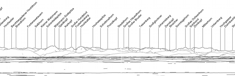
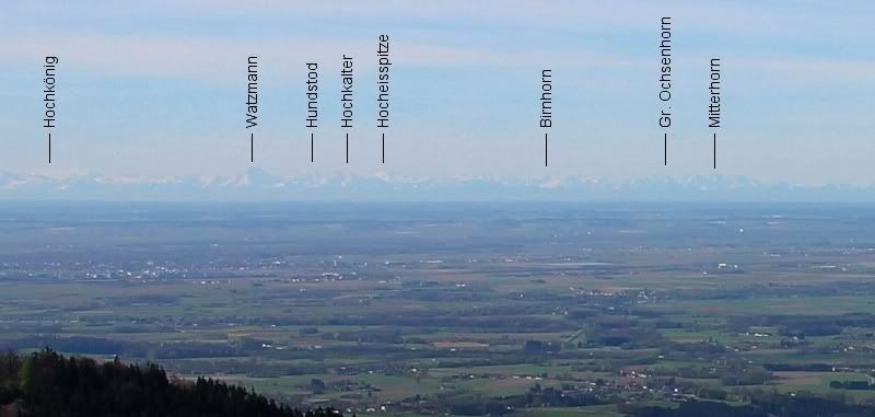
The new PeakFinder website is online!
 
http://www.peakfinder.org shows from any location a 360° panoramic view with the names of all mountains and peaks.
 
To plan, explore, print (pdf) and to link with your favorite peaks…


***************

Die neue PeakFinder Webseite ist online!

www.peakfinder.org zeigt von einem beliebigen Standort ein 360° Bergpanorama mit den Namen aller Gipfel.
 
Zum Planen, Entdecken, Ausdrucken (pdf).
 
***************
 
I hope you like the new website. I am looking forward to your feedback.
 
Best regards
Fabio


Kommentare (10)


Kommentar hinzufügen

bergpfad73 hat gesagt: Hidden advertisement?
Gesendet am 22. September 2012 um 15:21
This looks more like hidden advertisement for a mobile app... The one described in an older post returns better and more useful results.

PeakFinder hat gesagt: RE:Hidden advertisement?
Gesendet am 22. September 2012 um 15:39
Hi Bergpfad

I really think (and hope) the new PeakFinder website will be useful for hikers. It let them easily explore the panoramic views for the next trip. On the website users can also create Pdfs and print them out for the next hike. I also tried to make the user interface very simple and clear to make it accessible for many people.

I'm very interested in your opinion. What do you like more on the udeuschle page? The 3D style of rendering? May be I can improve PeakFinder in future versions with your tipps.

Best regards
Fabio

Herbert hat gesagt: RE:Hidden advertisement?
Gesendet am 23. September 2012 um 21:21
Hi Fabio,
to be honest I must say I agree 70% with Bergpfad, that Uwe Deuschles page returns better results.
I respect your work, but at Uwes page the main advantage is, that he obviously has access to a lot more accurate digital altitude model, it seems to be more exact than yours (or the rendering is more accurate).
He also has more named peaks (I compared this recently with 2 of my newer pictures), and the colored 3D rendering shows immediately how far a respective peak is away (otherwise it is often difficult to see if a peak is in front or in the back of another one - especially if you compare the view on a foto).
I also like the settings, so that one can specify the height of the camera above ground, and the angle and exact direction of the view.

On the other hand, what I like on your page more, is that one can move the view with the cursor, and zoom in and out with "+" and "-".
If the zoom would have 2 steps more on the "+" side, that would be great, and if the height of the camera above ground could be specified!
In this case I wouldn't miss the settings on Uwe's page to much, but the colored rendering and the number of peaks he has is a big advantage.
On a PC, especially with a big screen and strong resolution, the wishes of the users are possibly higher than on a smartphone. :-)
However, thanks for the application, it works well and especially it is very fast.
Best regards, Herbert

PeakFinder hat gesagt: RE:Hidden advertisement?
Gesendet am 25. September 2012 um 11:02
Hi Herbert

Thanks a lot for your detailed answer. This helps a lot to improve future versions of PeakFinder.

You are right that Uwe uses probably a more detailed elevation model. Both projects are using the data from the same source (viewfinderpanoramas.org). But I guess Uwe uses the 1’ resolution (about 30 meters) and for performance reasons PeakFinder uses the 3’ resolution (about 90 meters). In the next release I’ll try to switch also to the 1’ resolution. I think the first 20 kilometers need to be rendered with this resolution only. So I won’t be a big performance issue.

PeakFinder uses the data from openstreetmap.org and geonames.org for the peak directory. Uwe uses also geonames.org and some data of viewfinderpanoramas.org. I think both directories are more or less the same. But the way of displaying the peak names is different. Uwe tries to write down all names in the picture. PeakFinder labels the most prominent peaks only. The other peaks can be shown with the help of the ‘digital binoculars’ (a single click on the panorama or on the binoculars icon). This allows you also to display more information about a peak (distance, position, …). Both implementations have pros and cons I guess.

I see, there is still lot of potential for improvements. I’ll add more zoom levels soon and I’ll try to give the drawing a better perspective for close and far peaks.

Thanks again
Fabio

Jules hat gesagt:
Gesendet am 26. September 2012 um 06:29
Bello, mi piace!

Francesco hat gesagt:
Gesendet am 26. September 2012 um 06:31
..Anche a me come Jules piace.
grazie.!!!

PeakFinder hat gesagt: Zoom Level added
Gesendet am 28. September 2012 um 11:40
I just added a new zoom level and increased the maximum distance of the calculation to 320km.

Here is an example view from Grandsberg (Bayerischer Wald):
http://www.peakfinder.org/?lat=48.9464&lng=12.8505&name=Grandsberg&ele=760&zoom=7&dir=179


bulbiferum hat gesagt:
Gesendet am 29. September 2012 um 14:32
Hi Fabio

Yesterday I have loaded a new pano on www.alpen-panoramen.de and therefore I have used peakfinder und udeuschle to mark the peaks. The pano was made on the Illhorn.
After that compare I think udeuschle is more precisely. Therefore the handling in peakfinder is simpler and faster. So normally I use peakfinder but if the silhouette is complicated I use udeuschle.
By the way i have found an error. The Brunegghorn has, according to the peakfinder, an altitude of 2833m. Which is wrong. The correct value is 3833m. Udeuschle was correct.

PeakFinder hat gesagt: RE:
Gesendet am 1. Oktober 2012 um 11:10
Hi

Thanks for your answer. Thats very good.
The main goal of the PeakFinder webpage was a simple user interface for the 'average' user and a result that will be returned quickly. In future versions I'll try to add more details to the drawings.

I just corrected the Brunegghorn on openstreetmaps.org. That usually takes some days until its visible in PeakFinder.

Best regards
Fabio

Schneemann hat gesagt: RE:
Gesendet am 2. Oktober 2012 um 19:38
Its a great software, congratulations. It is really fast and easy-to-use.
However, if you want hints for improvements. I think the peakfinder often does not name those mountains, which are not at the horizon, but in front of other mountains. I do not know what criteria are used to identify peaks which shall be named...but I would prefer some more mountains to be named. Especially also those mountains which are in the middle of the picture.


Kommentar hinzufügen»