
The Nipple - (almost) Jeff Davis Peak - Markleeville Peak
|
||||||||||||||||||||


Today's plan was a tour at the south end of Hope Valley. 3 Peaks which can easily be combined in an day: The Nipple, Jeff Davis Peak and Markleeville Peak. However, in order to get to the very top of Jeff Davis Peak, I would have had to be a little braver (or would have needed a partner with a rope), because the scramble on the south side to the summit is rather exposed and unpleasantly brittle.
My starting point is 8 miles south of Highway 88 off of Blue Lake Road, there's a small forest road there. I walk along this dirt road westwards, cross the little stream and then up the hill. After a while I leave this road and hike up a rather steep washout to the extended north ridge of The Nipple. From here I follow the ridge and later walk up the north flank and get to the actual "nipple", which can easily be climbed from east.
In order to get to my next goal, Jeff Davis Peak, I walk down on the south side of it's east ridge, pretty much in direction east, all the way to Blue Lake Road. No need to be afraid of bushwhack here, there isn't much of that and if you run into some, it can easily be bypassed. After crossing Blue Lake Road, I follow the hiking path eastwards which leads up to a ridge north of Jeff Davis Peak and get to the base of the impressive decomposing volcanic plug. There is obviously no access to the top for me from this side, so I walk around the mountain to its south side, where I find the access to the described route.
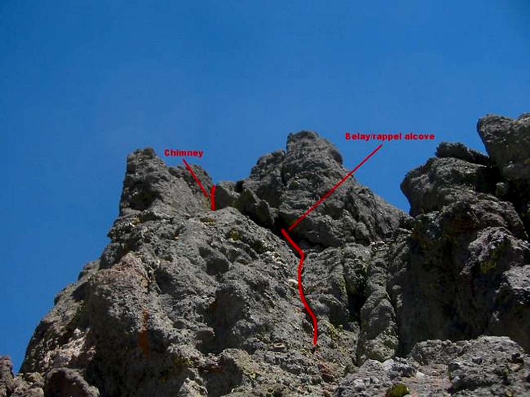
The first scramble about a third way up to a sandy slope is relatively easy (class II-III), but then it gets spicy and unfortunately there's a lot of loose rock too. From here I climb about half way up but then get scared, turn around and climb back down (which is not a piece of cake!). I definitely need a very good day (or a partner with a rope) in order to master this "scramble".
In order to get to my last goal today, Markleeville Peak, I walk back north and follow a path which leads to a saddle south of Markleeville Peak. From there I hike to the summit bypassing P. 8961 on the east side, trying to avoid the shrubs there. After a break I then hike back down to my starting point descending southwest in the west flank of the mountain.
My starting point is 8 miles south of Highway 88 off of Blue Lake Road, there's a small forest road there. I walk along this dirt road westwards, cross the little stream and then up the hill. After a while I leave this road and hike up a rather steep washout to the extended north ridge of The Nipple. From here I follow the ridge and later walk up the north flank and get to the actual "nipple", which can easily be climbed from east.
In order to get to my next goal, Jeff Davis Peak, I walk down on the south side of it's east ridge, pretty much in direction east, all the way to Blue Lake Road. No need to be afraid of bushwhack here, there isn't much of that and if you run into some, it can easily be bypassed. After crossing Blue Lake Road, I follow the hiking path eastwards which leads up to a ridge north of Jeff Davis Peak and get to the base of the impressive decomposing volcanic plug. There is obviously no access to the top for me from this side, so I walk around the mountain to its south side, where I find the access to the described route.
The first scramble about a third way up to a sandy slope is relatively easy (class II-III), but then it gets spicy and unfortunately there's a lot of loose rock too. From here I climb about half way up but then get scared, turn around and climb back down (which is not a piece of cake!). I definitely need a very good day (or a partner with a rope) in order to master this "scramble".
In order to get to my last goal today, Markleeville Peak, I walk back north and follow a path which leads to a saddle south of Markleeville Peak. From there I hike to the summit bypassing P. 8961 on the east side, trying to avoid the shrubs there. After a break I then hike back down to my starting point descending southwest in the west flank of the mountain.
Tourengänger:
 360
360
Minimap
0Km
Klicke um zu zeichnen. Klicke auf den letzten Punkt um das Zeichnen zu beenden
Galerie

")


 flower")

![That's the nipple on to of the [peak78386 The Nipple]](https://f.hikr.org/files/1770384s.jpg "That's the nipple on to of the [peak78386 The Nipple]")
 Blue Lake")

 from The Nipple")


 Pussypaws, Cistanthe umbellata")


")


Kommentare