FAQ
Einloggen
Anmeldung
Home
Journal
Regionen
Fotos
Geo
Map
Comm
Leute
Deutsch
▶
◀
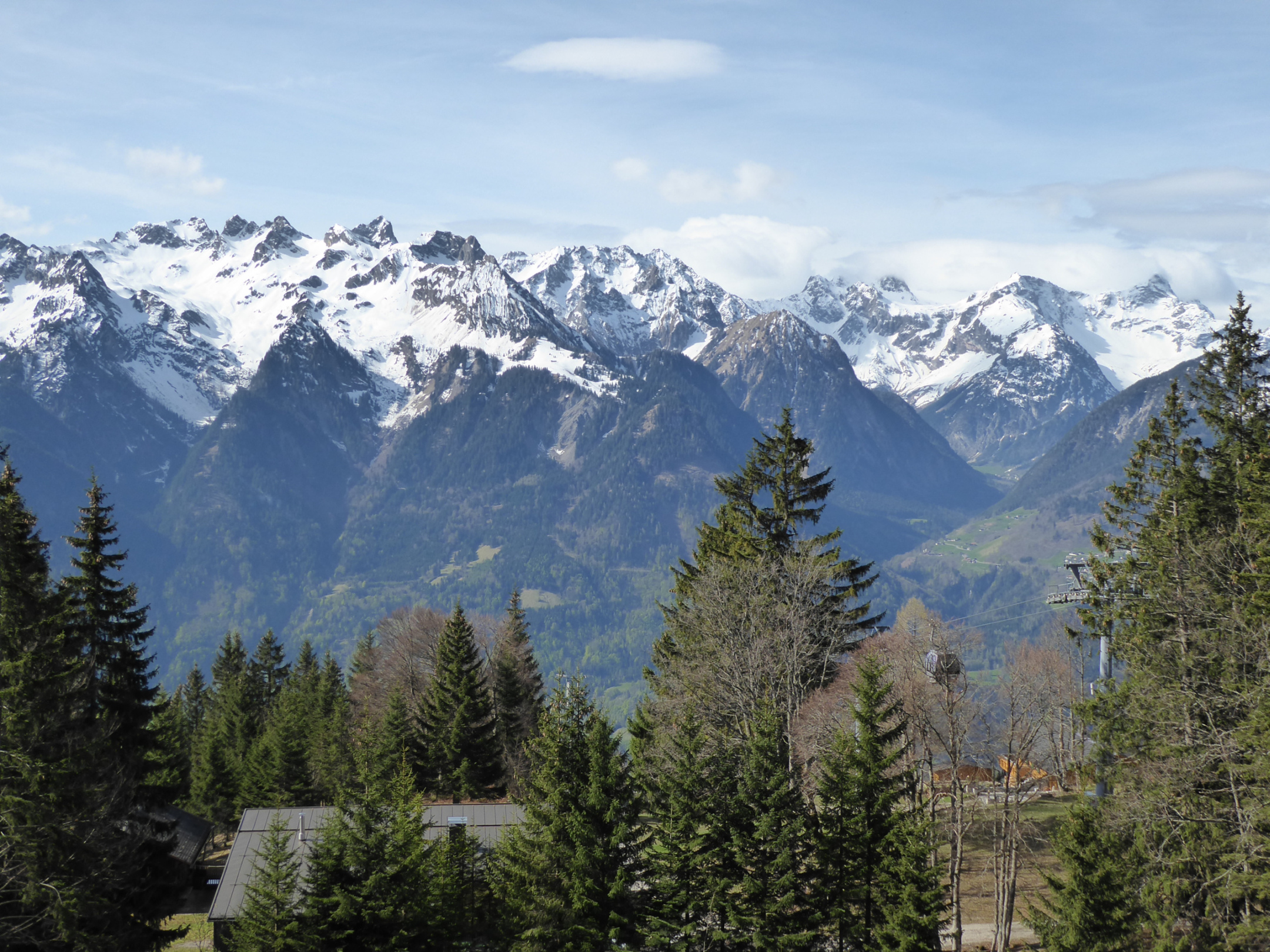
Oberhalb der Muttersberg Alpe - Blick hinüber zum Brandner Tal mit der Schesaplana.
Hoher Fraßen
Kommentare
Kommentar hinzufügen
Kommentar hinzufügen»
Um einen Kommentar zu hinterlassen, musst du
eingeloggt sein
.
Ort Fotos
Nach Publikationsdatum
« Zurück
Vor »
25
auf 27 Fotos
Hoher Fraßen
Schafgufel
Österreich
»
Nördliche Ostalpen
»
Lechquellengebirge
zu Favoriten hinzufügen
Auf dem Bild
Schesaplana (2964m.)
Gipfel in 87 Tourenberichte, 1674 Foto(s).
Geo-Tags:
CH-GR
,
A
,
A-V
Schesaplana 2964m.
Panüeler Kopf (2859m.)
Gipfel in 9 Tourenberichte, 664 Foto(s).
Geo-Tags:
A
Panüeler Kopf 2859m.
Brandner Wildberg (2788m.)
Gipfel in 1 Tourenbericht, 154 Foto(s).
Geo-Tags:
A
Brandner Wildberg 2788m.
Zimba (2643m.)
Gipfel in 14 Tourenberichte, 1146 Foto(s).
Geo-Tags:
A
Zimba 2643m.
Brandner Mittagspitze (2557m.)
Gipfel in 1 Tourenbericht, 176 Foto(s).
Geo-Tags:
A
Brandner Mittagspitze 2557m.
Wasenspitze (2009m.)
Gipfel in 0 Tourenberichte, 12 Foto(s).
Geo-Tags:
A
Wasenspitze 2009m.
Schafgufel (2351m.)
Gipfel in 1 Tourenbericht, 27 Foto(s).
Geo-Tags:
A
Schafgufel 2351m.
Gottvaterspitze (2438m.)
Gipfel in 3 Tourenberichte, 55 Foto(s).
Geo-Tags:
A
Gottvaterspitze 2438m.
Großer Valkastiel (2449m.)
Gipfel in 6 Tourenberichte, 92 Foto(s).
Geo-Tags:
A
Großer Valkastiel 2449m.
Schlagwörter
Communities
©
Jackthepot
, Hochgeladen am 7. Mai 2015 um 23:57.
Fotografiert am 26. April 2015 um 09:59 mit einer
DMC-TZ71 (Panasonic)
Reduzierte Grösse
Siehe in Originalgrösse
Diese Seite wurde
192
mal angezeigt
Benutzer Homepage
Journal
Gipfel
Fotos
Favoriten
Freunde
Sende mir eine Nachricht
Info
Bitte warten...


Kommentare