-

Deutsch
Wanderhütte Grümel 1050 m
Geo-Tags: CH-ZG
In der Nähe von: Morgartenberg, Gottschalkenberg / Muetegg, Unterägeri, Chlausenchappeli
Fotos (1)
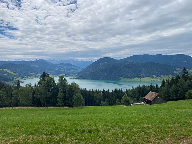
Blick zum Ägerisee. © Makubu
Minimap
0Km
Klicke um zu zeichnen. Klicke auf den letzten Punkt um das Zeichnen zu beenden
Hikr.org hat noch keinen Tourenbericht für diesen Wegpunkt.
Du kannst jetzt einen Tourenbericht eintragen, oder suchen in der "In der Nähe" Liste.
Du kannst jetzt einen Tourenbericht eintragen, oder suchen in der "In der Nähe" Liste.
Berichte in der Nähe
| Zug | T2 |
8 Jan 24
|
 Vom Bodensee zum Genfer See: Unterägeri - Zug 9|29
Die neunte Etappe des Alpenpanoramaweges ist mit 13 km eine recht kurze Etappe. Sowohl die Höhenmeter als auch der höchste Punkt mit 852 m sollte bei diesen Bedingungen machbar sein. Auch die Bilder auf Schweizmobil versprachen keine besonderen Höhepunkte. Im Winter ist das allerdings eine ganz andere Nummer.
Der...
Publiziert von
9. Januar 2024 um 13:37
(Fotos:26 | Geodaten:1)
| Schwyz | T2 |
3 Jan 24
|
 Vom Bodensee zum Genfer See: Einsiedeln - Unterägeri 8|29
Bevor Sturm und Schnee Einzug halten, wollte ich noch eine weitere Etappe auf dem Alpenpanoramaweg wandern und das ist mir auch gut gelungen. Als ich in Einsiedeln begann, strahlte die Sonne von einem blauen Himmel.
Am Anfang wieder die übliche Asphaltstraße, aber beim Aufstieg zum Chatzenstrick wurde es mir nicht nur...
Publiziert von
4. Januar 2024 um 14:00
(Fotos:31 | Geodaten:1)
| Schwyz | T1 |
17 Dez 23
|
 Morgartenberg
Être à la fois au-dessus des nuages mais en-dessous de la ligne de neige réduit souvent les zones où aller randonner. Cette fois-ci, bonne pioche avec le plateau de Rothenthurm et le Morgartenberg - même si au départ de la nouvelle gare de Sattel (828m), ce n'était pas encore complètement sûr !
Il y a même des...
Publiziert von
24. Dezember 2023 um 11:55
(Fotos:6 | Geodaten:1)
| Zug | T2 |
8 Nov 23
|
 Höhronen bis Morgartenberg
Ich hatte beim heutigen Zwischenhoch keine Lust auf Schneekontakt (wenn schon, dann eine rechte Skitour) und ging ins tiefer gelegene Alpenvorland. Ich wählte den landschaftlich sehr lohnenden und abwechsungsreichen "Halbmarathon" von Biberbrugg über den Höhronen und weiter zum Morgartenberg oberhalb des Ägerisees. Es ist dies...
Publiziert von
8. November 2023 um 23:33
(Fotos:22)
| Schwyz | T2 |
27 Jul 23
|
 Kammwanderung von Biberbrugg nach Unterägeri
Von Biberbrugg aus wandere ich zuerst nordwärts bis ein Bächlein überquert werden muss. Dann führt ein Wurzelweg in Zickzacks steil nach oben. Landschaftlich schön, im Ohr aber immer die Motorgeräusche der stark befahrenen Strasse im Tal. Nach einem Zwischenstück auf einer Forststrasse geht’s wieder steil hinauf zur...
Publiziert von
29. Juli 2023 um 16:52
(Fotos:24 | Geodaten:1)
| Zug | T3 L |
14 Jul 23
|
 Chaiserlich?
Chaiserstock. Da denkt man an einen stolzen Gipfel mit hohen Wänden, einem Hängegletscher vielleicht gar. Nix von alledem: Eine Wiesenfläche mit Kreuz, umgeben von Tannen. Durchaus etwas chaiserlich ist allerdings der Tief- (ja, man kann fast von Tiefblick) sprechen) und Weitblick, auf den türkisen Ägerisee und hinaus ins...
Publiziert von
15. Juli 2023 um 11:15
(Fotos:11)


