-

Deutsch
Mount Tamalpais - East Peak 784 m
22 Aug 15
Geo-Tags: USA, US-CA
In der Nähe von: Dad O'Rourke's Bench, Pantoll Ranger Station
Fotos (1)
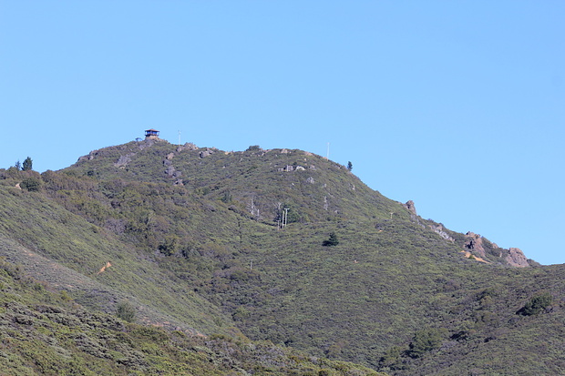
Looking back to the highest point of Mount Tamalpais, the East Peak This didn't used to be the highest point of Mount Tamalpais. The West peak, now the mountain's second highest peak, used to be 7m higher than the East Peak before it was flattened for the radar dome construction there. © 360
Minimap
0Km
Klicke um zu zeichnen. Klicke auf den letzten Punkt um das Zeichnen zu beenden
Tourenberichte (2)
| California | T2 |
22 Aug 15
|
 Mount Tamalpais
Mount Tamalpais (or Mount Tam how the locals call it) is a very popular mountain north of San Francisco. I climbed it once already in a rather long hike, all the way from Stinson Beach. Some friends who live in the Bay Area know that I like to hike and asked me to "guide" a tour up there.
Due to the various hiking experience...
Publiziert von
19. Juni 2016 um 20:42
(Fotos:8 | Geodaten:1)
| California | T2 |
4 Dez 13
|
 Mount Tamalpais - a very scenic loop from Stinson Beach
Mount Tamalpais (the locals call it Mount Tam) is probably one of the most popular outdoors playground in the San Francisco Bay Area, not just for hikers but also mountain bikers. Due to it's steep slopes on all sides it offers spectacular views over the surrounding cities, the rolling hills, the Pacific Ocean and the bay with all...
Publiziert von
6. Dezember 2013 um 16:12
(Fotos:24 | Kommentare:4 | Geodaten:1)
Hikr.org hat wenige Berichte für diesen Wegpunkt.
Du kannst jetzt einen Tourenbericht eintragen, oder suchen in der "In der Nähe" Liste.
Du kannst jetzt einen Tourenbericht eintragen, oder suchen in der "In der Nähe" Liste.
Berichte in der Nähe
| California | T2 |
30 Jul 15
|
 Trails am Mount Tamalpais
Der Mount Tamalpais State Park ist ein Naherholungsgebiet San Franciscos, dort gibt es einige Wanderrouten und unter der Woche herrscht wenig Andrang. Unser Freund macht den Guide, das gefällt ihm heute besser als für diese legendäre Obstfirma zu programmieren.An der Belvedere, einer Seitenstraßedirekt gegenüber vom Strand...
Publiziert von
5. September 2015 um 19:41
(Fotos:32)
