-

Deutsch
Jacks Peak 3004 m
14 Nov 14
Geo-Tags: USA, US-CA, Desolation Wilderness
In der Nähe von: Pyramid Peak, Little Pyramid, Mount Price, Mount Agassiz
Fotos (31)
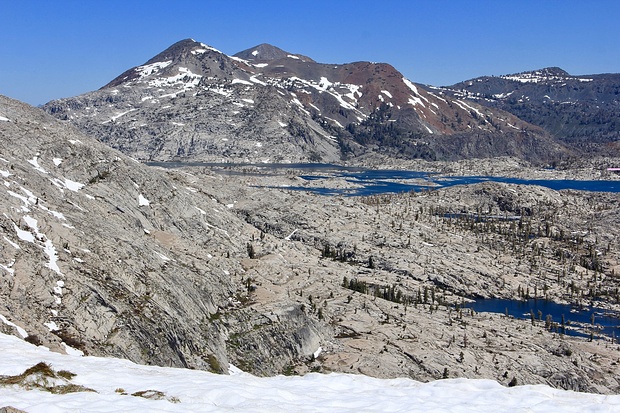
View to Lake Aloha and Dicks and Jacks Peak © 360
Minimap
0Km
Klicke um zu zeichnen. Klicke auf den letzten Punkt um das Zeichnen zu beenden
Tourenberichte (1)
| California | T4 I |
14 Nov 14
|
 Jacks and Dicks Peak - Desolation Wilderness at its best
Dicks and Jacks Peak have caught my attention on many of my hikes in the Tahoe area already. These two mountains are both quite high (almost 10K ft) and stick out. You see them from many other peaks in the area. However, a day hike to these two peaks is about 14 miles long with an altitude gain of more than 4000 ft, no matter from...
Publiziert von
16. November 2014 um 07:29
(Fotos:22 | Kommentare:1 | Geodaten:1)
Hikr.org hat wenige Berichte für diesen Wegpunkt.
Du kannst jetzt einen Tourenbericht eintragen, oder suchen in der "In der Nähe" Liste.
Du kannst jetzt einen Tourenbericht eintragen, oder suchen in der "In der Nähe" Liste.
Berichte in der Nähe
| California | T5- II |
23 Okt 20
|
 Little Pyramid - the "unnamed" beauty
Update October 23, 2020 see below*
June 24, 2016:
During my hike last week I saw a mountain which caught my attention. To my surprise, after consulting the USGS topo map, I found out that it didn't have a name on any map, even though it is quite a prominent peak with a topographical prominence to its neighbor (Mount Agassiz)...
Publiziert von
9. August 2016 um 14:24
(Fotos:31 | Geodaten:2)
| California | T3+ I |
15 Jun 18
|
 Pyramid Peak via Rocky Canyon
The general setup was more or less the same as last week, not too much time for an extended hike so something with little ramp-up time was needed. Since I also didn't have time to prepare any new hikes I just decided to go back to Pyramid Peak once again. In order to make sure I would reach my goal on this day, I didn't only start...
Publiziert von
19. Juni 2018 um 19:02
(Fotos:8 | Geodaten:1)
| California | T4- WT1 |
15 Dez 17
|
 Phipps Peak - A nice snowshoe & hike roundtrip from Emerald Bay
California's weather is currently influenced by a so-called "blocking high" off the Atlantic coast which brought us nice warm and sunny T-Shirt days down in the valley for almost all of December so far (and it doesn't look like it will change any time soon). Unfortunately this prevents the winter storms from rolling in and the...
Publiziert von
18. Dezember 2017 um 16:42
(Fotos:20 | Geodaten:1)
| California | T4+ |
30 Jun 17
|
 Of melting snow, "falling horsetails" and a pyramid
The first time I saw the Horsetail Falls, I wasn't all that impressed. Due to the drought then and the late season, the waterfall had nothing but a tiny bit of water trickling down from the Desolation Valley. The current situation with record amounts of melting snow should give the falls a much more impressive character. In...
Publiziert von
3. Juli 2017 um 21:15
(Fotos:21 | Geodaten:1)
| California | WS+ |
21 Apr 17
|
 Maggies Peaks - Closed for the Season? No way!
Maggie's South Peak is a very popular hiking destinations in the Tahoe area. It is an easy marked path from Inspiration Point (a view point at Emerald Bay) to the top. During the summer months hundreds if not thousands of people visit this peak every year which offers a nice view to Lake Tahoe. During the winter, the peak is in...
Publiziert von
23. April 2017 um 06:50
(Fotos:19 | Geodaten:1)


