-

Deutsch
Helfenbergflue - Kreuz 948 m
13 Jul 22
Geo-Tags: CH-SO
In der Nähe von: Roggenflue - Aussichtsplattform, Waldenburg, Langenbruck, Hinteri Egg / Hinderi Egg
Fotos (1)
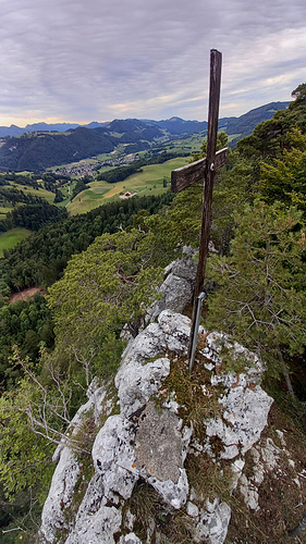
Beim Gipfelkreuz der Helfenbergflue. © ᴅinu
Minimap
0Km
Klicke um zu zeichnen. Klicke auf den letzten Punkt um das Zeichnen zu beenden
Tourenberichte (2)
| Solothurn | T4+ III |
13 Jul 22
|
 Limmernschlucht, Ellbogen, Helfenberg & Helfenbergfluh
Da mir das Urnerland in den letzten Wochen zu viele Wolken hatte machte ich mich dieses mal auf in Richtung Jura. Hier wurde ich bei dieser Feierabendwanderung mit purem Sonnenschein empfangen.
Parkiert habe ich im unteren Teil der Limmernschlucht. Da ich die Höhlen der Limmernschlucht noch nie besucht hatte, machte ich mich...
Publiziert von
15. Juli 2022 um 17:10
(Fotos:37 | Geodaten:1)
| Solothurn | T4 |
16 Nov 16
|
") Überschreitung Helfenbergflue und Helfenberg (Bilstein)
Überschreitung Helfenbergflue und Helfenberg (Bilstein)
Da musste ich doch bei einem Hikr-Eintrag feststellen, dass ich die Überschreitung der Helfenbergflue nicht kenne. Das änderte sich heute. Ein kleines Zeitfenster, dass zusätzlich durch eine Verhersage mit Regen (80%) zusätzlich gekürzt wurde, sollte genutz werden. Also: W-O-Überschreitung der Helfenbergflue....
Publiziert von
19. November 2016 um 11:49
(Fotos:12 | Kommentare:1 | Geodaten:1)
Hikr.org hat wenige Berichte für diesen Wegpunkt.
Du kannst jetzt einen Tourenbericht eintragen, oder suchen in der "In der Nähe" Liste.
Du kannst jetzt einen Tourenbericht eintragen, oder suchen in der "In der Nähe" Liste.
Berichte in der Nähe
| Solothurn | T2 |
20 Mär 24
|
 Roggenflue - ab Thalbrücke, mit neuer Abstiegsvariante
Mehr als 20 Male war ich bereits auf dem Roggen unterwegs - und stets können alternative Wege gefunden werden …
Beliebt ist dabei der wandermässig leicht erhöhte Ansprüche stellende Aufstieg ab Thalbrücke, Parkplatz am Stadttor. Bereits der Steig hoch zur Burg Alt Falkenstein ist ein malerischer; der weitere -...
Publiziert von
8. April 2024 um 21:56
(Fotos:21 | Geodaten:1)
| Solothurn | T5 |
19 Mär 24
|
 kurz & knackig: Ravellen
Weiter geht's mit Pendenzen ennet dem Jura.
Schon zig mal auf Hikr beschrieben, habe ich nicht mehr viel zu melden.
An der Schlüsselstelle wähle ich das (neue?) Fixseil, was aber, wie ich mir mittlerweile habe sagen lassen, gar nicht einfacher ist, als der Aufstieg durch die Rinne. Auch dient es mir mehr als psychologische...
Publiziert von
19. März 2024 um 22:34
(Fotos:27)
| Basel Land | T5 |
13 Feb 24
|
 kurz & knackig: Zustieg Gerstel durch das Südcouloir
Beim Durchblättern des SAC-Kletterführers "Basler Jura" auf diesen Zustieg gestossen.
NB: Im Gerstel gilt ab Januar bis Juni das amtliche Kletterverbot in den Sektoren der Grossen Südwand und Stilli Wand. Obwohl seit Jahren keine Brutaktivität dort stattfindet. In allen anderen Sektoren vom Spitzenflühli bis zum...
Publiziert von
13. Februar 2024 um 21:00
(Fotos:23 | Kommentare:4)
| Basel Land | T5 |
30 Jan 24
|
 kurz & knackig: Schwängiflüeli Westgrat
Dies dürfte wohl meine letzte Vertigo-Pendenz in der Nordwestschweiz gewesen sein und auch die happigste.
Rundtour von/nach Langenbruck.
Auf dem WW bis Hof Schwengi. Dann auf dem Forstweg zu Pt. 859. Hier auf schmalem Pfad auf den Grat. Den Pfeiler bei Pt 944 umgehe ich rechts, um dann auf einer Rampe links auf den Grat zu...
Publiziert von
31. Januar 2024 um 09:40
(Fotos:22 | Kommentare:7)


