-

Deutsch
Dicks Peak 3040 m
14 Nov 14
Geo-Tags: USA, US-CA, Desolation Wilderness
In der Nähe von: Little Pyramid, Mount Price, Mount Agassiz, Jacks Peak
Fotos (43)
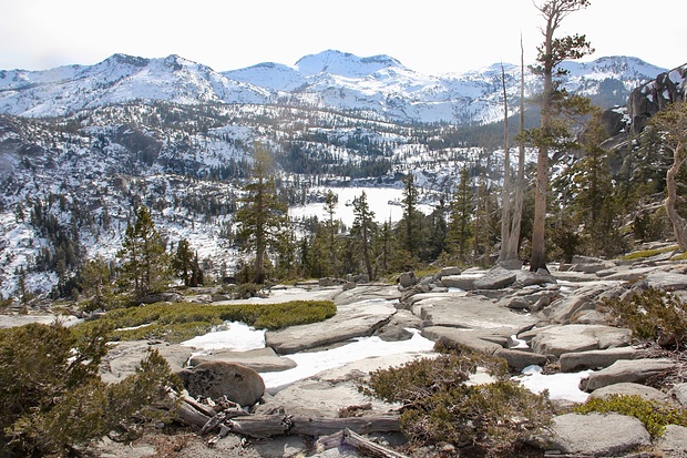
Lower Velma Lake © 360
Minimap
0Km
Klicke um zu zeichnen. Klicke auf den letzten Punkt um das Zeichnen zu beenden
Tourenberichte (1)
| California | T4 I |
14 Nov 14
|
 Jacks and Dicks Peak - Desolation Wilderness at its best
Dicks and Jacks Peak have caught my attention on many of my hikes in the Tahoe area already. These two mountains are both quite high (almost 10K ft) and stick out. You see them from many other peaks in the area. However, a day hike to these two peaks is about 14 miles long with an altitude gain of more than 4000 ft, no matter from...
Publiziert von
16. November 2014 um 07:29
(Fotos:22 | Kommentare:1 | Geodaten:1)
Hikr.org hat wenige Berichte für diesen Wegpunkt.
Du kannst jetzt einen Tourenbericht eintragen, oder suchen in der "In der Nähe" Liste.
Du kannst jetzt einen Tourenbericht eintragen, oder suchen in der "In der Nähe" Liste.
Berichte in der Nähe
| California | T5- II |
23 Okt 20
|
 Little Pyramid - the "unnamed" beauty
Update October 23, 2020 see below*
June 24, 2016:
During my hike last week I saw a mountain which caught my attention. To my surprise, after consulting the USGS topo map, I found out that it didn't have a name on any map, even though it is quite a prominent peak with a topographical prominence to its neighbor (Mount Agassiz)...
Publiziert von
9. August 2016 um 14:24
(Fotos:31 | Geodaten:2)
| California | T4- WT1 |
15 Dez 17
|
 Phipps Peak - A nice snowshoe & hike roundtrip from Emerald Bay
California's weather is currently influenced by a so-called "blocking high" off the Atlantic coast which brought us nice warm and sunny T-Shirt days down in the valley for almost all of December so far (and it doesn't look like it will change any time soon). Unfortunately this prevents the winter storms from rolling in and the...
Publiziert von
18. Dezember 2017 um 16:42
(Fotos:20 | Geodaten:1)
| California | WS+ |
21 Apr 17
|
 Maggies Peaks - Closed for the Season? No way!
Maggie's South Peak is a very popular hiking destinations in the Tahoe area. It is an easy marked path from Inspiration Point (a view point at Emerald Bay) to the top. During the summer months hundreds if not thousands of people visit this peak every year which offers a nice view to Lake Tahoe. During the winter, the peak is in...
Publiziert von
23. April 2017 um 06:50
(Fotos:19 | Geodaten:1)
| California | T5 II |
29 Mai 15
|
 Hike and Bike: Keith's Dome - Echo Peak and Flagpole Peak
My Swiss hiking projects typically didn't have the same starting and end point, because I was almost exclusively traveling with public transportation and I would often choose to end my hike at a different train station or bus stop than the beginning of my hike. Here in California public transportation is basically non-existent, in...
Publiziert von
3. Juni 2015 um 06:09
(Fotos:28 | Geodaten:1)
| California | T1 |
31 Mär 15
|
 Cascade Falls
Left the car at the Inspiration Point viewpoint, and walked through the closed campground to the trailhead. The trail to the falls was short and easy (though a bit rocky in places). Near the end, the trail isn't obvious (the ground is covered in granite slabs, and people go in all directions), but you can climb down some rocks to...
Publiziert von
6. April 2015 um 08:32
(Fotos:4 | Geodaten:1)


