
Redertenstock south ascent
|
||||||||||||||||||||


Tuesday was shaping to be the last sunny day before a long spell of bad weather, so I decided to take a day off from work and spend it in the mountains. For quite some time I'd been wanting to try and repeat the route described earlier on hikr by  PStraub and Delta. The idea to try this variant was born the last time I was on Redertenstock and read the printout of Delta's report, attached to the Gipfelbuch.
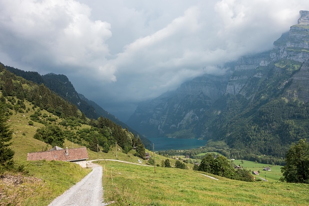
After a long and uneventful approach via a gravel road to Ober Längenegg, the actual route started. One should aim for the right of the two gullies going down from the Mutteri-Rederten face. A large boulder slightly above the buildings of Ober Längenegg indicates the right heading.
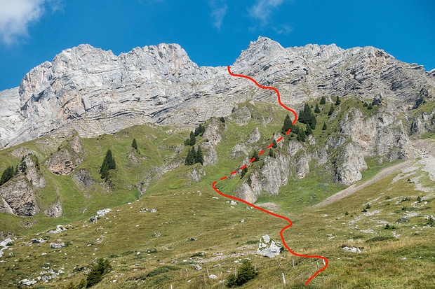
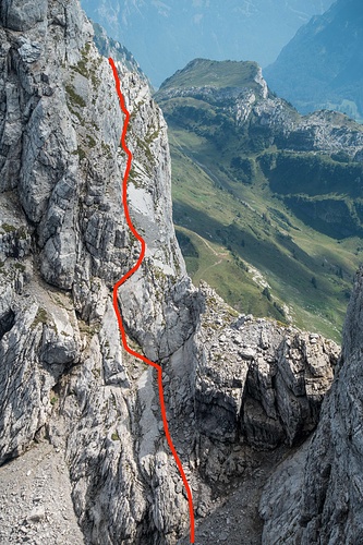
The scrambling in the gully is mostly easy and follows a staircase-like rocky riverbed. But on 2 occasions I decided to stray to the right a little, and there, in the grass, an ice axe proved to be helpful. The gully ends with an open rocky area, which one should climb straight up (keeping close to its left edge makes most sense) until the base of the actual Redertenstock face. From there an easily visible system of grassy ledges on the left leads straight to the notch between Mutteristock and Redertenstock.
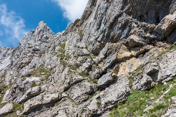
From the notch I traversed the rocky ledge across the south face and through easy grassy/rocky slopes reached the summit. The ledge is much less scary than it may seem from pictures - there's always good holds in the rock above the ledge for additional protection.
While on the summit I enjoyed listening to singing/yodeling in harmony by a group visiting the neighboring Mutteristock.
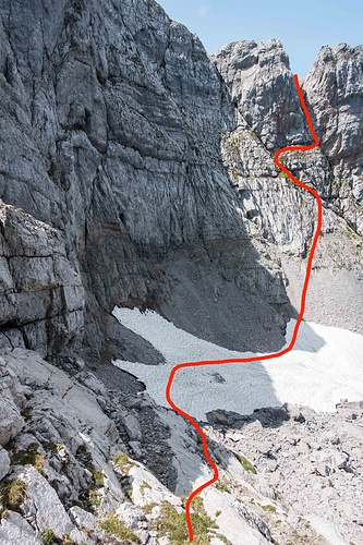
After a rather long break, I retraced my steps through the rocky ledge back to the notch in the ridge between Mutteristock and Redertenstock. From there, an easy downclimb leads to the snowy basin between the summits. I reached the summit of Mutteristock via the right couloir in its east face.
My original plan was to continue the hike from Mutteristock along the ridge to the entrance into Ochsenchopf east ridge, inspect it from up close and decide whether I would be comfortable tackling it. But I noticed some suspiciously looking clouds approaching, so instead I decided to skip the ridge and follow the white-red-white trail toward Oberalp at first, then leave it at some point to head toward Durchgäng and back down to Klöntal.
The best thing to do would have probably been to stay on the marked trail until the vicinity of P.1905 and then turn south toward Durchgäng. Instead I made the mistake of leaving the trail around P.1989 and spent a lot of extra time navigating the karst fields until I reached the grass at Durchgäng. Here I heard a thunder, so my decision to abandon the exploration of Ochsenchopf turned out to be a good one.
I couldn't see any trails or markings leading down from Durchgäng, so I headed directly toward the building at Ochsenfeld. From there I traversed west until I joined a well-visible path zigzagging down toward the forest. It's important to traverse west from the building, as continuing south or south-east one would reach the abrupt end of the pasture with vertical drops below.
Upon reaching the lower pasture (Unter Stafel), I couldn't find the path that goes east toward Ralli. I believe the path is marked inaccurately on the map (too much to the south). In the end I crossed the small forest pathless and joined the gravel road somewhat below Ralli.
I reached the car the minute the first rain drop fell, and drove directly into the thunderstorm down to Glarus.
PStraub and Delta. The idea to try this variant was born the last time I was on Redertenstock and read the printout of Delta's report, attached to the Gipfelbuch.After a long and uneventful approach via a gravel road to Ober Längenegg, the actual route started. One should aim for the right of the two gullies going down from the Mutteri-Rederten face. A large boulder slightly above the buildings of Ober Längenegg indicates the right heading.
The scrambling in the gully is mostly easy and follows a staircase-like rocky riverbed. But on 2 occasions I decided to stray to the right a little, and there, in the grass, an ice axe proved to be helpful. The gully ends with an open rocky area, which one should climb straight up (keeping close to its left edge makes most sense) until the base of the actual Redertenstock face. From there an easily visible system of grassy ledges on the left leads straight to the notch between Mutteristock and Redertenstock.
From the notch I traversed the rocky ledge across the south face and through easy grassy/rocky slopes reached the summit. The ledge is much less scary than it may seem from pictures - there's always good holds in the rock above the ledge for additional protection.
While on the summit I enjoyed listening to singing/yodeling in harmony by a group visiting the neighboring Mutteristock.
After a rather long break, I retraced my steps through the rocky ledge back to the notch in the ridge between Mutteristock and Redertenstock. From there, an easy downclimb leads to the snowy basin between the summits. I reached the summit of Mutteristock via the right couloir in its east face.
My original plan was to continue the hike from Mutteristock along the ridge to the entrance into Ochsenchopf east ridge, inspect it from up close and decide whether I would be comfortable tackling it. But I noticed some suspiciously looking clouds approaching, so instead I decided to skip the ridge and follow the white-red-white trail toward Oberalp at first, then leave it at some point to head toward Durchgäng and back down to Klöntal.
The best thing to do would have probably been to stay on the marked trail until the vicinity of P.1905 and then turn south toward Durchgäng. Instead I made the mistake of leaving the trail around P.1989 and spent a lot of extra time navigating the karst fields until I reached the grass at Durchgäng. Here I heard a thunder, so my decision to abandon the exploration of Ochsenchopf turned out to be a good one.
I couldn't see any trails or markings leading down from Durchgäng, so I headed directly toward the building at Ochsenfeld. From there I traversed west until I joined a well-visible path zigzagging down toward the forest. It's important to traverse west from the building, as continuing south or south-east one would reach the abrupt end of the pasture with vertical drops below.
Upon reaching the lower pasture (Unter Stafel), I couldn't find the path that goes east toward Ralli. I believe the path is marked inaccurately on the map (too much to the south). In the end I crossed the small forest pathless and joined the gravel road somewhat below Ralli.
I reached the car the minute the first rain drop fell, and drove directly into the thunderstorm down to Glarus.
Tourengänger:
 pave
pave
Minimap
0Km
Klicke um zu zeichnen. Klicke auf den letzten Punkt um das Zeichnen zu beenden
Galerie
")


 route to Redertenstock under the yellow face")


 Bitte warten...


Kommentare (3)