
Leave it or ski Leavitt?
|
||||||||||||||||||||


In Northern California we had an unusually long lasting period of very hot weather for more than a week now. The high temperatures were up to 110°F (43°C)! Luckily where we live, we have two options to flee the heat, we either go to the Pacific Coast where temperatures are always cool even during the hottest days in the summer, or up to higher elevations in the Sierra Nevada. Last week we spent a long weekend at the coast, but this week I wanted to go back to the mountains. The question was: Should I do another ski tour or leave my skis at home and just go hiking? After seeing that Sonora Pass had opened after it's long winter break just a little more that a week ago, it was very clear to me that it would be another ski tour.
The pass is almost 3000m high and there are plenty of interesting mountains in this zone. After looking at the "current condition" website of Sonora Pass, it was also clear that there was plenty of snow left for a "summer ski adventure". The most popular goal for back-country skiers in this area is Leavitt Peak. It offers an interesting option for advanced skiers, the Y-couloir which is on it's north face.
After a good night rest at the Baker campground in the Kennedy Meadows, I get up at 4 AM, pack up my stuff and drive to Sonora Pass. Shortly before sunrise I start my tour. My plan is to get to Leavitt Peak mostly on the west side of the ridge (which connects Sonora Pass with Leavitt Peak) to the base of the peak and then via Y-couloir to it's top. Soon I have to realize that the west side of the ridge doesn't have snow any more in quite a few places close to the ridge (probably because during storms the Sierra ridges are exposed to the sometimes strong west winds). For the first half of the tour, to the point where the PCT gets into the Emigrant Wilderness, it would have made sense to completely stay on the east side (the way I skied back).
At this point I see my goal of the day the first time. It looks quite far away and there is definitely a portage necessary now. It's unclear how far though and I don't have a good overview to see what the best way there is without having to take off my skis too often. I follow the PCT for a while find some snow again and then on and off some snow and snow free patches. On the way back, after getting a good overview of the west side of the ridge from the summit, I can minimize the booting to less than a quarter mile.
At the northern base of Leavitt Peak I then inspect the Y-couloir. It's not too steep and I would feel comfortable to go up there with the crampons and ice axe I brought along and even ski down again. However, there are quite a few falling rocks which came down during my approach already and I see plenty of "rock scars" in the snow in the couloir. Therefore, I decide to take the less steep and safe route on the northwest side to the top. The steepness there hoovers around 30 and 35 degrees and no immediate threat from above has to be expected. The very last stretch to high point then is snow free and I walk there.
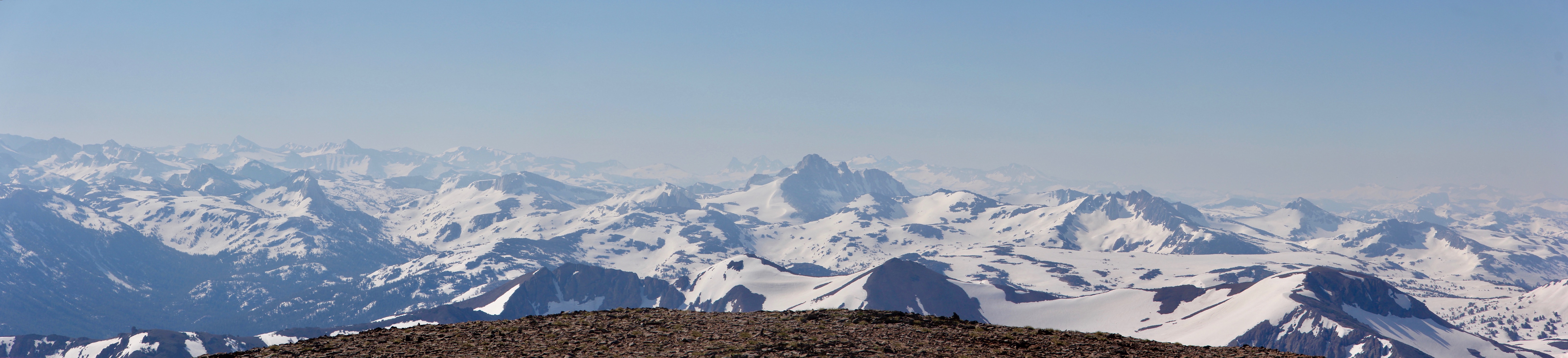
The top of Leavitt Peak is quite flat but the view southeast offers some very nice glances to hundreds of interesting peaks, mostly unknown to me. I recognize a few like Mount Dana or the Matterhorn Peak. After a break I then ski back to the pass. The snow is very pleasant for skiing where it's steep enough and looks like the wavily ocean in some places. Thanks to the good overview of the west side of the ridge connecting Sonora Pass to Leavitt Peak from the summit I had, I can now avoid most of the snow free patches I ran into on the way to the top and can reduce the booting to a minimum.
PS: "Leave it" is in the title, because I actually thought about turning around during somewhat annoying portages (and thinking that I would have to do them again on the way out), but I'm glad my ambition to reach the summit was strong enough. Not only because it was a fabulous view into - for me a new and - interesting part of the Sierras from at relatively high peak, but also because I was able to see an easier way out than in
The pass is almost 3000m high and there are plenty of interesting mountains in this zone. After looking at the "current condition" website of Sonora Pass, it was also clear that there was plenty of snow left for a "summer ski adventure". The most popular goal for back-country skiers in this area is Leavitt Peak. It offers an interesting option for advanced skiers, the Y-couloir which is on it's north face.
After a good night rest at the Baker campground in the Kennedy Meadows, I get up at 4 AM, pack up my stuff and drive to Sonora Pass. Shortly before sunrise I start my tour. My plan is to get to Leavitt Peak mostly on the west side of the ridge (which connects Sonora Pass with Leavitt Peak) to the base of the peak and then via Y-couloir to it's top. Soon I have to realize that the west side of the ridge doesn't have snow any more in quite a few places close to the ridge (probably because during storms the Sierra ridges are exposed to the sometimes strong west winds). For the first half of the tour, to the point where the PCT gets into the Emigrant Wilderness, it would have made sense to completely stay on the east side (the way I skied back).
At this point I see my goal of the day the first time. It looks quite far away and there is definitely a portage necessary now. It's unclear how far though and I don't have a good overview to see what the best way there is without having to take off my skis too often. I follow the PCT for a while find some snow again and then on and off some snow and snow free patches. On the way back, after getting a good overview of the west side of the ridge from the summit, I can minimize the booting to less than a quarter mile.
At the northern base of Leavitt Peak I then inspect the Y-couloir. It's not too steep and I would feel comfortable to go up there with the crampons and ice axe I brought along and even ski down again. However, there are quite a few falling rocks which came down during my approach already and I see plenty of "rock scars" in the snow in the couloir. Therefore, I decide to take the less steep and safe route on the northwest side to the top. The steepness there hoovers around 30 and 35 degrees and no immediate threat from above has to be expected. The very last stretch to high point then is snow free and I walk there.
The top of Leavitt Peak is quite flat but the view southeast offers some very nice glances to hundreds of interesting peaks, mostly unknown to me. I recognize a few like Mount Dana or the Matterhorn Peak. After a break I then ski back to the pass. The snow is very pleasant for skiing where it's steep enough and looks like the wavily ocean in some places. Thanks to the good overview of the west side of the ridge connecting Sonora Pass to Leavitt Peak from the summit I had, I can now avoid most of the snow free patches I ran into on the way to the top and can reduce the booting to a minimum.
PS: "Leave it" is in the title, because I actually thought about turning around during somewhat annoying portages (and thinking that I would have to do them again on the way out), but I'm glad my ambition to reach the summit was strong enough. Not only because it was a fabulous view into - for me a new and - interesting part of the Sierras from at relatively high peak, but also because I was able to see an easier way out than in
Tourengänger:
 360
360
Minimap
0Km
Klicke um zu zeichnen. Klicke auf den letzten Punkt um das Zeichnen zu beenden
Galerie


 seems to be the most popular skiing goal in the area")

![Almost at the base of Leavitt Peak<br />The "blood snow" is [https://en.wikipedia.org/wiki/Watermelon_snow Watermelon snow]: Chlamydomonas nivalis](https://f.hikr.org/files/2399943s.jpg "Almost at the base of Leavitt Peak<br />The \"blood snow\" is [https://en.wikipedia.org/wiki/Watermelon_snow Watermelon snow]: Chlamydomonas nivalis")
 for my way up, but it was too active (falling rocks) so I went up the less steep and safe way on the right hand side")


 might make sense by foot, in order to not lose too much altitude<br />It's hard to see on the way up, because there's some brushes too!")


![More [https://en.wikipedia.org/wiki/Watermelon_snow watermelon snow]: Chlamydomonas nivalis<br />](https://f.hikr.org/files/2399953s.jpg "More [https://en.wikipedia.org/wiki/Watermelon_snow watermelon snow]: Chlamydomonas nivalis<br />")


![The route from Sonora Pass to Leavitt Peak<br /><b>Read [http://www.hikr.org/gallery/photo2401825.html?post_id=121972#1 this] and [http://www.hikr.org/gallery/photo2399934.html?post_id=121972#1 that] if you plan to repeat</b><br /><span style="background: white"> <span style="color: rgb(245,255,10); margin-left: 5px">27°-29°</span><span style="color: rgb(250,183,0); margin-left: 5px">30°-31°</span><span style="color: rgb(254,121,0); margin-left: 5px">32°-34°</span><span style="color: rgb(255,0,0); margin-left: 5px">35°-45°</span><span style="color: rgb(135,0,225); margin-left: 5px">46°-50°</span><span style="color: rgb(0,0,255); margin-left: 5px">51°-59°</span><span style="color: rgb(0,0,0); margin-left: 5px">60°+</span>. </span><br />[http://CalTopo.com]<br /><br />](https://f.hikr.org/files/2400050s.jpg "The route from Sonora Pass to Leavitt Peak<br /><b>Read [http://www.hikr.org/gallery/photo2401825.html?post_id=121972#1 this] and [http://www.hikr.org/gallery/photo2399934.html?post_id=121972#1 that] if you plan to repeat</b><br /><span style=\"background: white\"> <span style=\"color: rgb(245,255,10); margin-left: 5px\">27°-29°</span><span style=\"color: rgb(250,183,0); margin-left: 5px\">30°-31°</span><span style=\"color: rgb(254,121,0); margin-left: 5px\">32°-34°</span><span style=\"color: rgb(255,0,0); margin-left: 5px\">35°-45°</span><span style=\"color: rgb(135,0,225); margin-left: 5px\">46°-50°</span><span style=\"color: rgb(0,0,255); margin-left: 5px\">51°-59°</span><span style=\"color: rgb(0,0,0); margin-left: 5px\">60°+</span>. </span><br />[http://CalTopo.com]<br /><br />")
 Bitte warten...

Kommentare (3)